


Tel Aviv and Israel V1.0_Beta
Israeli objects scenery
More 100 ibjects of Tel Aviv city,Or yehuda industrial zone,Yehud buildings,power plants os Hadera,Sde-Dov and Ashkelon…
Ashalim solar power plant in negev,Nesher cement plant,Ramla,few objects in Haifa,Jerusalem,bridge,new Central Bus station of Tel Aviv,Yaffa church and mosque,Rotschild street and more.
Developed by Bagaev Alexandr
![]()


Israel VFR – Objects
Add various objects and landmarks in Israeli cities.
Tel Aviv, Jerusalem, Haifa and much more are now enhanced with real world models.
Also, cell towers are added across Israel.
Some models were converted from other simulators Israel’s addon by the permission of their creators (IXPT, ISP).
Some models created from the scratch.
by Bar Rodoy
Required: PBK Effects Library by Photosbykev
Download Israel VFR – Objects
![]()

Eilat City
Eilat City. The main Eilat landmark buildings such as Hilton, King Solomon, Imax are converted form X-Plane 11 scenery by omer1234. Thanks for him to allow me to share that scenery. This scenery includes main hotels near waterfront, the Lagoona, IMAX, the underwater restaurant and the Port of Eilat
Developed by Piter449
![]()

Israel VFR – Cell Towers
This scenery adds cell towers all across Israel based on Israel Ministry of Environmental Protection GIS data.
Developed by Bar Rodoy
![]()

Israel VFR – Vegetation
Adds dates, citrus and olives orchards and forests based on Israel’s Ministry of Agriculture and Rural Development GIS data.
Developed by Bar Rodoy
![]()

ETM12 Enhanced Terrain Mesh 12m for Israel
Enhanced Terrain Mesh 12m for Israel – version 1.00
This is an Enhanced Terrain Mesh ALOS PALSAR RTC 0,41 arc sec (12 meters).
Developed by Gjanosh61
![]()


Herzliya Airport
Herzliya Airport (ICAO: LLHZ) is an airport located in the city of Herzliya in central Israel. The airport is mainly used by flight schools and for general aviation. It has no terminal.
Developed by Bar Rodoy
Download Airport
![]()
Download Photoreal


Haifa Airport
Haifa Airport (IATA: HFA, ICAO: LLHA), also known as U Michaeli Airport is a small international airport located in Haifa, Israel. It is located to the east of the city, close to Kishon Port and Israel Shipyards and mainly serves civilian flights, with some military usage. Most passenger flights utilizing the airport are domestic operations to Eilat and Tel Aviv. The airport is named after Uri Michaeli, one of the pioneers of Jewish aviation and one of the founders of aviation in Israel.
Developed by Bar Rodoy and Alexander Bagaev
Required: Windy Things by trfsto
Download Airport
![]()
Download Photoreal


Rosh Pina Airport
Rosh Pina Airport (ICAO: LLIB), sometimes called Mahanayim Airport due to its proximity to Mahanayim, is an Israeli airport located in Rosh Pinna, near the Safed-Hatzor-Rosh Pina Industrial Park. The airport is located 16 km from Safed, 29 km from Tiberias and 30 km from Kiryat Shmona.
Developed by Bar Rodoy
Download Airport
![]()
Download Photoreal


Megiddo Airfield
Megiddo Airfield (IATA: N/A, ICAO: LLMG), known as Shachar 7 by the Israel Defense Forces, is an Israeli airfield located in the Jezreel Valley near Tel Megiddo and 3 km (1.9 mi) southwest of Afula. Opened in 1942 as RAF Station Megiddo and was used as an auxiliary field to RAF Station Ramat David. It currently handles private and agricultural flights. It formerly served as an Israeli Air Force base and was decommissioned in the mid-1980s.
Developed by Bar Rodoy
Required: Windy Things by trfsto
Download Airport
![]()
Download Photoreal


Kiryat Shmona Airport
Kiryat Shmona Airport (IATA: KSW, ICAO: LLKS) is a public Israeli airport located 2 km east of the northern town of Kiryat Shmona. The airport is operated by Kiryat Shmona Travellers Inc.
Developed by Bar Rodoy
Required: Windy Things by trfsto
Download Airport
![]()


Bar Yehuda Airfield
Bar Yehuda Airfield (IATA: MTZ, ICAO: LLMZ), named after Israel Bar-Yehuda, is a small desert airfield located in the southern Judean desert, between Arad and Ein Gedi, west of the Dead Sea. Opened in 1963, it is just 4.2 km (2.6 mi) from the Masada fortress access and about one hour and a half drive from Jerusalem, Israel. The airfield is a public concession, mainly used as an alternate airport, and for charter and sightseeing flights.
Located at 1,240 ft (378 m) below mean sea level, Bar Yehuda Airfield is the lowest airport in the world.
Required: MSFS 2020 object library 200+ models – towers hangars to cones by colinj
Download Airport
![]()
Download Photoreal


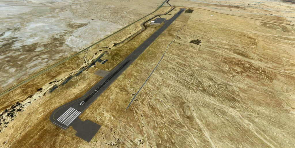
Ein Yahav Airfield
Ein Yahav Airfield (IATA: N/A, ICAO: LLEY), officially known as Sapir Airfield, is a small desert airfield in southern Israel’s Arabah between the Dead Sea and Eilat. The airfield is located across Highway 90 from Sapir, and not far from Ein Yahav. It was constructed in 1970, and since 1989 has had service to which operated by Elrom Airways to Sde Dov Airport in Tel Aviv.
Developed by Bar Rodoy
Required: Windy Things by trfsto
Download Airport
![]()


Fik Airfield
Fik Airfield (also known as Pik) (ICAO: LLFK) is an airfield in the Golan Heights, near the Israeli settlement and kibbutz Afik. The airfield is used for private aviation activity and operated by the Golan Regional Council. Fik has seen traffic drop in recent years, but is used by Elbit Systems to test their Unmanned aerial vehicles. The airfield was the site of Israel’s 2001 Kart racing championship, and there is talk of converting it into a race track.
Developed by Bar Rodoy
Required: Windy Things by trfsto
Download Airport
![]()
Download Photoreal

Rishon Lezion Airfield
Rishon Lezion Airfield (ICAO: LLRS) Located south west of the city of Rishon Lezion in the center district in Israel near Tel Aviv use as the main hub for light and sport aviaition
Developed by Bar Rodoy
Required: Windy Things by trfsto
Download Airport
![]()
Download Photoreal
![]()

Sde Dov Airport – Removal
Sde Dov Airport, also known as Dov Hoz Airport (IATA: SDV, ICAO: LLSD), closed in 2019, this scenery remove the airport from simulator
Developed by Bar Rodoy
![]()

Eilat Airport
Eilat Airport (IATA: ETH, ICAO: LLET) is a defunct airport located in Eilat, Israel. It was named after Arkia Airlines founder Yakov Hozman (Jacob Housman) and is located in the center of Eilat adjacent to Route 90 (The Arava Road). Due to its short runway and limited capacity it mainly handled domestic flights from Tel Aviv and Haifa Airports, while Uvda International Airport, located some 60 km north of the city handled Eilat’s international carriers.
developed by Piter449
![]()